Hey everyone,
I’m on the team over at General Laser, and I wanted to put together a complete overview of our Pocket2 handheld 3D LiDAR scanner. We’ve had a lot of questions pop up across various forums regarding workflow, accuracy, software compatibility, and specifically when you need (or don’t need) the external RTK module.
I put this guide together to help break down the tech, address common questions, and share a quick look under the hood.
What is the Pocket2?
The Pocket2 is a compact, walk-and-scan handheld reality capture device. It’s designed to bridge the gap between heavy, expensive terrestrial laser scanners and lightweight SLAM systems that lack precision.
Key Tech Specs:
-
Sensor Fusion: 40-channel 905nm LiDAR + 3x 2MP Global Shutter RGB cameras + IMU.
-
SLAM Engine: Driven by our proprietary MindSLAM® algorithm for real-time pixel-level data fusion and odometry.
-
Accuracy: Point cloud local relative accuracy better than 1 cm (0.4 in).
-
Sampling Rate: 200,000 points per second.
-
Range: Up to 40 m @ 10% reflectivity / 70 m @ 80% reflectivity.
-
Weight & Battery: ~790 g main unit with a ~120 min hot-swappable battery handle.
Understanding the Mapping Engine: Pure SLAM vs. RTK
One of the most frequent questions we get is: “Do I need the RTK module for my workflow?”
To answer that, it helps to understand how the system creates 3D models.
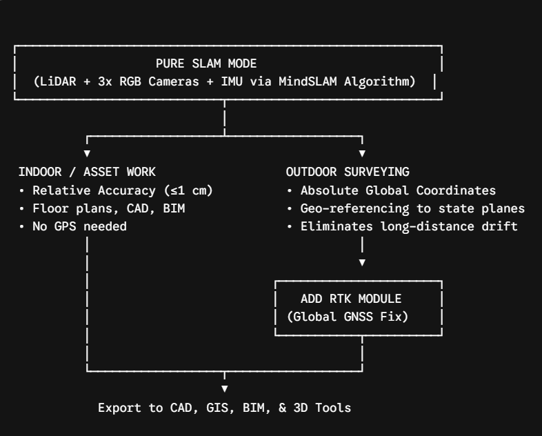
1. Pure SLAM Mode (Without RTK)
Out of the box, the Pocket2 uses visual-inertial LiDAR SLAM. As you walk through an environment, the MindSLAM algorithm matches geometry and optical features in real time to build a true-color point cloud.
-
Best for: Indoor scanning, MEP rooms, architecture, stock management, interior renovations, asset inspection, and digital twin/3D asset creation.
-
Why it works: In these environments, you care about relative dimensions (e.g., Is this wall 10.5 feet long? Will this machinery fit?). You do not need the model locked to a global latitude/longitude coordinate.
2. RTK Mode (With GNSS/RTK Module)
When you add the RTK module, the system ties the SLAM trajectory to real-time satellite positioning networks (NTRIP / Base Station).
-
Best for: Land surveying, civil engineering, forestry, outdoor infrastructure mapping, and large-scale site tracking.
-
Why you need it:
-
Absolute Geo-referencing: Automatically locks your point cloud into WGS84 or local coordinate systems with sub-5 cm absolute accuracy.
-
Drift Control: On long outdoor loops or linear assets (like scanning 1 km of road), pure SLAM can slowly accumulate subtle drift. RTK locks the trajectory to absolute points.
-
Eliminates Manual GCPs: Replaces time-consuming Ground Control Point (GCP) setups in the field.
-
Software Ecosystem: MindCloud
We built the hardware to work seamlessly with our software pipeline so you don’t spend hours in post-processing:
-
MindCloud Go (Mobile App): Provides live point-cloud previews on your phone while scanning, ensuring no missing data or blind spots before you leave the site.
-
MindCloud Studio (PC): Handles automated point cloud registration, color fusion, noise filtering, and mesh generation.
-
Export Compatibility: Seamlessly exports to
.las,.laz,.ply,.e57, and.ptsfor easy drop-in into Revit, AutoCAD, CloudCompare, Blender, or Unreal Engine.
Summary: Which Setup Should You Choose?
-
Choose the base Pocket2 if: Your primary work is indoors, in tight spaces, or focused on localized asset capture where relative accuracy is key.
-
Add the RTK Module if: You do large-scale outdoor mapping, land surveys, or need your data to align directly with GIS or CAD survey coordinates.
Feel free to drop any technical questions, workflow inquiries, or sample data requests in the thread below! Happy to answer them for you.